In this post Viola Ross-Smith discusses her recent paper ‘Modelling flight heights of lesser black-backed gulls and great skuas from GPS: A Bayesian approach‘.
Although the need for renewable energy and its benefits are now widely recognised, this technology does not come without implications for biodiversity and the environment. For this reason, it’s important to assess and quantify the potential risks of renewables to wildlife and their habitats. Technology for harnessing wind energy has progressed rapidly in recent decades, and large wind turbine arrays are being installed many locations around the world. In addition to being displaced from their habitats by these structures, flying animals can be injured or killed if they collide with them. The extent of this problem is difficult to assess, particularly when the wind turbines concerned are at sea.
Bats, terrestrial birds and insects will all cross the sea, but seabirds are the animals most likely to be routinely at risk of collision with offshore wind turbines. As long-lived species that produce few young each year, the risk to breeding adults is especially important in terms of impact on species’ populations. One of the key parameters in determining the risk that wind turbines pose to birds is height. Spinning turbine blades are the most dangerous element of a wind farm, so birds flying at blade height are those most at risk of collision. But how do we measure seabird flight height? The answer is with GPS, or more specifically by attaching a small GPS tracking device to an individual seabird to record its position in 3D. However, there is error inherent in the way that GPS measures height, which must be dealt with before this technology can be used to draw meaningful conclusions about the threat wind turbines represent.
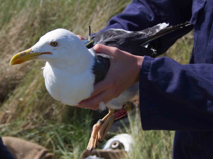
We used GPS tags to record the flight profiles of 25 lesser black-backed gulls and 24 great skuas breeding at protected British colonies. We had up to four seasons’ information for some individuals, comprising hundreds of thousands of flight height measurements, all with associated error. We solved this error problem analytically, using a Bayesian state-space model with two parts: (1) a model of the true distribution of flight heights of birds, and (2) a model of the error in the GPS readings. By modelling both together, we produced estimated distributions of flight heights that accounted for the error in our GPS readings, and were therefore more accurate than distributions that would be produced otherwise.
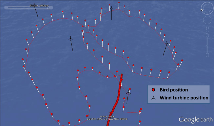
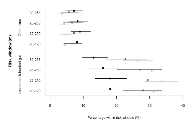
As behaviour affects a bird’s flight height, in section (1) of the model we estimated a different height distribution for flying birds in different locations (over land, near the coast, or in offshore marine environments) and at different times of day (daylight, twilight and dark). This showed that lesser black-backed gulls flew significantly lower at sea than over land, and significantly lower at night than during the day. Great skuas flew lower than lesser black-backed gulls, and did not show significant relationships between flight height, location and time of day. Importantly, our models found that both species primarily flew beneath the height of wind turbines blades. We analysed this for several different ‘collision risk windows’, corresponding to the airspace swept by rotor blades for different turbine designs, the results of which supported other studies in suggesting that these species are safer when the turbine structure is raised, so that the lower limit of the turbine blade is 30 m above sea level.
Section (2) of our analysis modelled the error in the GPS readings. As well as altitude, speed and other variables, the GPS tags take a measurement called ‘dilution of precision’. This captures information about the satellite geometry for each reading, which affects the accuracy of the readings. We included dilution of precision in our model of the error. With optimal satellite geometry, we estimated 95% of the altitude estimates for lesser black-backed gulls were within ±17 m of the true height. This figure rose to ±46 m with the worst satellite geometry. These figures are likely to vary with device, location, time of year, weather and many other factors, so cannot necessarily be generalised to other situations. However, they demonstrate that the altitude error introduced from GPS devices can be substantial and can vary considerably over time, and therefore it is important for modelling approaches to account for it.
Our study shows that Bayesian state-space models are an effective way of resolving the problem of error associated with GPS tracking data, and can be used to provide important information on seabirds’ risk of collision with offshore wind turbines. Our approach could be applied to other seabird species to assess their collision risk, which is useful as more wind farms are being built worldwide, but it could also be used on a wider selection of species in many different scenarios. Either way, we hope our approach provides a new alternative in modelling animal movement as reliably as possible at a time when tracking is increasingly being used as a tool to inform management and conservation.

With the Third runway location planned at Heathrow , this will impact the daily morning and evening migration of about 4000 gulls birds who will fly directly across the new runway at about 200ft average , sometimes lower ! , The numbers vary , sometime its a couple every few second , sometime a larger number, always changing. At present planes have already climbed on the existing two runways. above their height for their evening Roosts in the fields and reservoirs to the West of Heathrow A full study really needs to be done as I can foresee bird-strikes. ( we also have geese flocks as well following a similar path , but not so many and not everyday). Landing issues will be less due to prevailing South West winds .
LikeLike