
Ruth Howison comments on recent article, Quantifying landscape-level land-use intensity patterns through radar-based remote sensing.
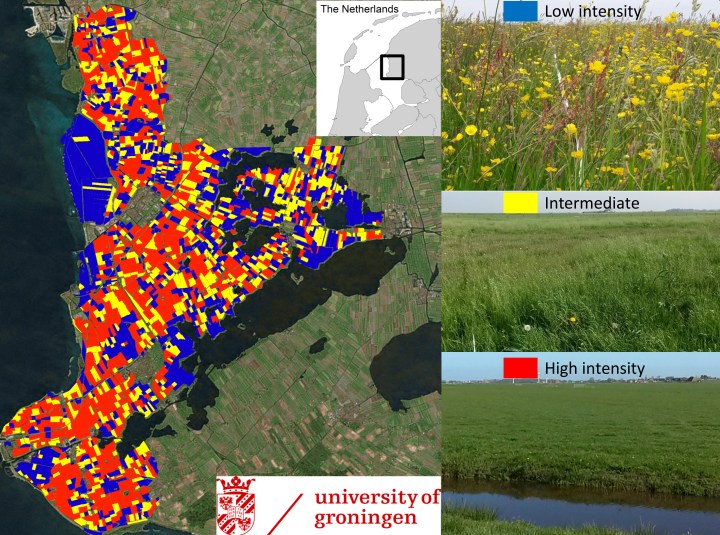
Sentinel 1 radar imagery strongly predicts agricultural land use intensity across whole landscapes at the resolution of individual fields. In combination with extensive ground surveys, we developed a new analytical technique to summarize temporal variation in radar satellite data (i.e. variation in surface roughness) in north-western Europe. Higher variation corresponded strongly to the frequently mown herb-poor fields whereas low variation corresponded to herb-rich fields managed by nature conservation, grazed by herbivores or with delayed mowing agreements (Figure 1.).
Recent data on biodiversity loss in rural landscapes increasingly call for reducing the negative impacts of intensive agricultural practices in Europe. This includes the reduction of too heavy drainage, fertilizer and pesticide inputs, mowing frequency, and soil tillage. We developed a new radar-based measure of temporal variability in vegetation structure, allowing to precisely quantify variation in land use intensity of grasslands over large spatial scales. This technique allows the worldwide quantification of patterns and changes in land use intensity at high temporal (12 days) and spatial (10 m) resolution.
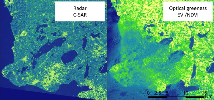
The launch of the ESA Sentinel-1 satellite, in April 2015, now offers exciting new possibilities for near real time monitoring of human impact on Earth’s ecosystems (Figure 2.). It is well recognised that increasing agricultural land use intensity leads to fragmentation of ecosystems and dramatic declines in natural diversity, such as plants, insects and birds. The pressing question was whether we could capture the intensity of spring mowing and fertilizer application in the dairy farming grasslands of north-western Europe, where meadow bird and insect populations are particularly vulnerable to increased agricultural disturbance. During spring ground nesting meadow birds are incubating their nests and insects are emerging from the soil after the cold winter. Too early mowing prevents these meadow bird chicks and insect larvae from reaching maturity. Although expensive agri-environmental schemes have aimed to mitigate the negative effects of agriculture on biodiversity, evaluations of these schemes thus far have shown few positive effects.
As a case study we focused on the iconic continental black-tailed godwit of which 80% of the western-Europe population breeds in the grasslands of The Netherlands. The godwit population has suffered dramatic declines from 120 000 breeding pairs in the 1960’s to the present day, where only 33 000 breeding pairs remain. A research team under the leadership of Theunis Piersma, University of Groningen, follows the population of godwits from their arrival in south-west Friesland in early spring until their departure for southward migration from mid-July to the end of August. All fields in the study area are scanned for godwits establishing their territories for nests from early March until May. These data were combined with the radar derived land use intensity map. We found that in 2016, godwits showed a clear preference for establishing their territories in fields with moderate land use intensity, more than in the low or high intensity fields. This preferred habitat of intermediate mowing and manuring, can now be mapped at the landscape scale.
Read the full article, Quantifying landscape-level land-use intensity patterns through radar-based remote sensing in Journal of Applied Ecology.

One thought on “New radar satellite imagery tracks agricultural land use intensity at landscape scales”