This blog post is part of the blog series ‘Authors in Asia’, to accompany the recent Virtual Issue in Journal of Applied Ecology. You can read other posts in this series here.
Minerva Singh is a PhD Candidate at the University of Cambridge and she is involved with the BES Conservation Ecology Special Interest Group. Her research focuses on using high resolution airborne data for mapping forest biophysical parameters and evaluating the impact of anthropogenic disturbances on them in the tropical ecosystems of the Greater Mekong region. In this post Minerva looks at the many forms of and factors driving forest loss.

Politically, the Greater Mekong sub-region (GMS) comprises of Myanmar, Thailand, Cambodia, Vietnam and Laos PDR. More than 50% of this area is still covered with forests which are home to many iconic and endangered species, notably the Indochinese tiger and Hainan langur among others. The region has been categorized as a biodiversity hotspot according to the Biodiversity Hotspot classification devised by Myers et al. (2000). Over the past few decades, several species including large mammals such as “soala” have been discovered or re-discovered in the GMS. Other notable species include the Annamite striped rabbit and gaur, among others. The region also has a high level of endemicity. For several decades during the 20th century, the region faced severe turbulence in the form of socio-political instability, decolonization, the Vietnam War and guerrilla warfare undertaken from jungle camps. This instability combined with prioritizing economic development over conservation (an attitude which may well have stemmed from colonial forestry management practices) has greatly shaped and influenced the forest cover dynamics of the GMS.

A recent report by WWF compiled in great detail the forest cover change in the GMS from 1973–2014 and examined the factors influencing forest loss in the region (WWF 2013). Since the 1970s, the entire region has lost about 30% of its total forest cover (Cambodia: 22%, Laos and Myanmar: 24%, and Thailand and Vietnam: 43%), as shown in the image above. Additionally, a substantial increase in forest fragmentation has been noted as well. Further, in a “business as usual” scenario (that the region follows the same development trajectory followed from 2002–09), the report has predicted a further 34% loss in forest cover and the reduction of core forest area down to 14%.

The high resolution forest loss map (2000–14) produced by Hansen et al. (2013) was also examined, and is shown above. An analysis of the Hansen data revealed that over the past decade and a half, Thailand has lost 1.99% of its forest cover area, while Cambodia has lost 9.65% of its forest cover area. Vietnam and Laos have lost 5.68% to 7.5% of total forest cover area. Leinenkugel et al. (2015) analyzed 500-m MODIS data from 2000–11 and found the entire region had a forest loss rate of 0.4% per annum. Petersen et al. (2015) further present that Cambodia and Vietnam have among the highest rates of per annum forest loss in the world; 14.4% and 7% respectively. Outside of Brazil and Indonesia, the GMS is fast emerging as a hotspot for deforestation. The GMS faces a serious deforestation threat and is losing its valuable forest cover at a rapid rate. Forest loss in the GMS comes in different forms – from small scale swidden agriculture, extraction of non-forest timber resources to clear cutting for timber harvesting, all the way to the establishment of plantations and infrastructure development.
Historically, slash-and-burn agriculture has been purported to be one of the major drivers of forest loss in the GMS. However, findings of the report and other research indicate that other factors, notably infrastructure development, population expansion and plantation agriculture are also very important drivers of forest loss in the region. For instance, Hansen et al. (2013) indicate that forest loss in Cambodia is correlated with an increase in world rubber prices (Hansen et al. 2013). While correlation does not imply causation, it would be useful to evaluate the role industrial scale plantation agriculture plays in influencing forest cover loss.
Over the past few years, Cambodia has seen a massive surge in economic land concessions, wherein both foreign and domestic investors are provided with leases for a long-term period. Davis et al. (2015) used a combination of official concession geolocation data and high resolution satellite data to examine the forest loss within these concessions from 2000–12. It was discovered that forest cover loss was significantly higher within the concessions (29% to 105%) than in comparable areas lying outside the concessions.
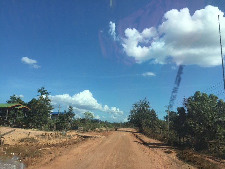
In addition to an upswing in cash crop production and large scale land acquisitions, the GMS has seen large scale infrastructure development in the form of road constructions, dam building, and mining operations, among others. Road construction (both in itself and as a by-product of other infrastructure development) is known to be a major driver of deforestation, biodiversity loss and forest fragmentation, and it is further facilitating incursion into the once remote and forested tracts of the GMS (the figure above shows an unpaved road cutting across forests in rural Lao PDR). Other infrastructure development programs, notably dam construction and other hydroelectric initiatives have contributed to forest loss in different parts of the GMS. Additionally, external macroeconomic factors act as an important, albeit underlying factor. In addition to international prices of commodity crops, China’s investment in the various infrastructure projects around the GMS could exacerbate the present situation.

Over the past few decades, the factors influencing forest loss have undergone a change. According to the WWF report, infrastructure development is a far more important factor than agricultural production. However, the shifting roles played by agriculture, selective logging, local resource extraction and timber harvesting cannot be neglected (as these may be harder to detect from satellite data). From the time of the Khmer empire (9th–15th century), the GMS has a long history of reconciling people and their livelihoods with forest cover persistence. As it were, forests that have gone several rounds of logging, resource use/production forests or even degraded forests can retain significant biodiversity (the figure above shows a male Grey Pansy butterfly in a production forest in Lao PDR).
However, reconciling biodiversity conservation with economic development is an extremely complex, and often contradictory, goal. At a fundamental level, it would require the combined efforts of academics, conservation managers and policymakers to re-define the basic concepts of what really constitutes development and how development can take place without decimation of nature. It is widely accepted that loss of forest resources greatly disempowers the local communities in the developing world (Forests Monitor 2006). The Nobel Laureate, Dr Amartya Sen, floated the concept of “development as freedom” which argues about the importance of looking beyond increasing incomes or per capita incomes and focusing on a more holistic form of development which increases individual freedom and the ability of individuals to exercise agency (Sen 2001). Arguably, the loss of forestry resources may deprive many forest dwelling communities of agency and self-determination (Harris & Lang 2014). Today, the GMS stands at the proverbial cross-roads. As road construction threatens to invade the last of Asia’s wilderness spots, the question remains if the forest resources of the GMS can withstand the existing rate and nature of “development”. Can “development” which comes at the cost of the destruction of valuable biodiversity and depriving the local communities of their agency really be called “development”?
References
Davis, K. F. et al. (2015) Accelerated deforestation driven by large-scale land acquisitions in Cambodia. Nature Geoscience, 8(10), pp. 772-775.
Forests Monitor (2006) Social Impacts of Logging. [Online]Available at: http://www.forestsmonitor.org/en/reports/550066/550082 [Accessed 05 December 2015].
Hansen, M. C. et al. (2013) High-resolution global maps of 21st-century forest cover change. Science, 342(6160), pp. 850-853.
Harris, P. G. & Lang, G. (2014) Routledge handbook of environment and society in Asia. s.l.:Routledge.
Leinenkugel, P., Wolters, M. L., Oppelt, N. & Kuenzer, C. (2015) Tree cover and forest cover dynamics in the Mekong Basin from 2001 to 2011. Remote Sensing of Environment, Issue 158, pp. 376-392.
Myers, N. et al. (2000) Biodiversity hotspots for conservation priorities. Nature, 403(6772), 853-858., 403(6772), pp. 853-858.
Petersen, R. et al. (2015) Satellites Uncover 5 Surprising Hotspots for Tree Cover Loss. [Online]
Available at: http://www.wri.org/blog/2015/09/satellites-uncover-5-surprising-hotspots-tree-cover-loss [Accessed 05 December 2015].
Sen, A. (2001) Development as freedom. Oxford: Oxford University Press.
WWF (2013) Ecosystems in the Greater Mekong: Past trends, current status, possible futures, s.l.: World Wide Fund For Nature.
