
Wildlife crossing structures are considered critical for animal movement, but how do you choose where best to build them? Guillaume Bastille-Rousseau presents tools for planning crossing structures and the recently published article, Optimizing the positioning of wildlife crossing structures using GPS telemetry.
Linear infrastructure development, including transportation and economic corridors, is considered to have outsized ecological impacts relative to their small physical footprints. In sub-Saharan Africa, over 53,000 km of development corridors (which frequently involves the construction of roads, railroads, and/or pipelines running in parallel) are being planned or are currently under construction, with a great number of these corridors occurring in largely pristine and undeveloped areas. These development corridors can limit animal movement, which has negative effects on nearby populations and ecosystem functioning.

such as this one pictured in Northern Kenya (Photo: AP/Save the Elephants)
Wildlife crossing structures such as over- and underpasses are recommended as a critical means of mitigating the negative impacts of linear features on animal movement. Recent development projects regularly involve the construction of a limited number of crossing structures, but the location of these structures can be a very contentious decision. The proliferation of animal GPS tracking provides a powerful means to use animal behaviour to facilitate the decision-making process.
GPS telemetry has rarely been used to assist the decision process, despite being highly informative in identifying areas where animals are likely to cross a future road, railway or pipeline and where a crossing structure could be useful in avoiding the risk for vehicle collision or maintaining connectivity within their range. Additionally, more and more GPS telemetry datasets are now openly and freely available.
We set out to develop approaches to leverage GPS telemetry in deciding where to put crossing structures, and more importantly how can they be used in optimising landscape planning decisions around infrastructure development projects. We developed and applied our approaches to a long-term dataset of African elephants’ movement within the northern part of Kenya, where the Lamu Port-South Sudan-Ethiopia-Transport (LAPSSET) corridor has been proposed for the coming years. This dataset was acquired thanks to a long-term collaboration between Save the Elephants and the Kenyan Wildlife Service.
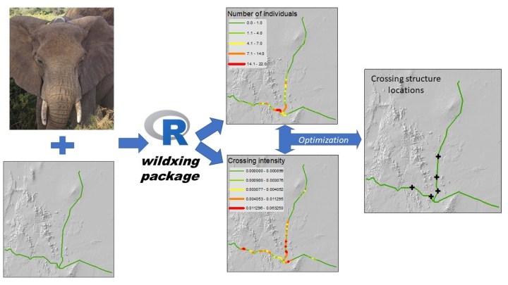
Through experimentation in this system, we ended up creating an algorithm that optimizes where to put crossing structures if we want to reduce the number of vehicle-wildlife collisions (assuming there will be no fences along the transportation corridor) and another algorithm that optimizes where to put crossing structures to maximize connectivity (assuming the whole corridor is fenced). To facilitate use of these approaches, we developed an R package called wildxing that implements the algorithms. This way, we hope that decision makers from all sorts of backgrounds can apply it to their system.
We applied each algorithm to each dataset (the representative sample of elephants and the whole dataset) and got different results regarding where we should put crossing structures. This indicates that understanding the context of the corridor (e.g. will it be fenced or not) and making sure the sample of tracked animals is representative are very important considerations. These tools can therefore not be applied blindly, but are a great addition in facilitating effective spatial planning. This is especially important given the limited budget already allocated to mitigation measures in most proposed developments.
Read the full article, Optimizing the positioning of wildlife crossing structures using GPS telemetry in Journal of Applied Ecology.

2 thoughts on “Optimizing the positioning of wildlife crossing structures for African elephants in Northern Kenya”