
Recent research from Marina Antongiovanni and colleagues estimates 47,000 fragments of Caatinga dry forests to be affected by chronic human disturbances. Here the authors look at how such effects are depicted, and demonstrate how this knowledge can help define large-scale conservation and management actions.
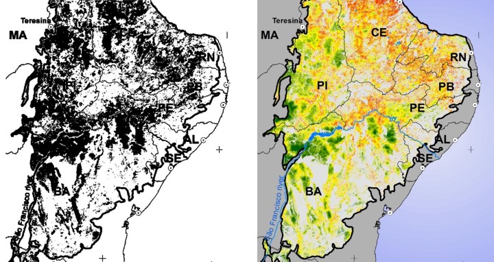
Fragmentation patterns, frequently depicted in black and white maps, are the basis of many conservation and management decisions. In our recent study in Journal of Applied Ecology, we demonstrate that, besides their size, shape and isolation, fragments can vary widely in quality due to chronic human disturbances.
Not only do many human activities cause habitat loss and fragmentation, but these and other activities can also cause degradation of remaining habitat. While the first processes are now easily recorded by satellite images at large scales, habitat degradation is more easily detected locally in the field. When we get inside some habitat fragments, they seem quite pristine. By contrast, in others one can see human footprints and trails, dirty roads, fire marks, tree stumps, wood piles, ammunition capsules, cattle, cattle dung, dogs, cats, and rubbish. When we leave the place, we have a strong conviction that those sites have been seriously disturbed.

We integrated remote, official information on 14 independent variables reflecting spatial variation in five anthropogenic disturbance vectors: human population, infrastructure, grazing, logging, and fire. Then we coloured each pixel and each fragment of the Caatinga ecosystem according its disturbance level.
The coloured pattern that emerged was very different to the black and white figure we described a few years ago. We could recognise that habitat quality changes considerably among regions. We could see that fragment size is a poor predictor of fragment quality. The quality of a fragment is much more context-dependent than we previously assumed. Also, we could recognise accentuated edge effects at larger edge depths.
Furthermore, we clearly saw that different human disturbance forces are acting on different parts of the Caatinga landscape, requiring different conservation and management actions. Overgrazing was widespread in the eastern part of the region, requiring specific state regulations. Fire was more important on the north, requiring policy enforcement. The impact of infrastructures was almost everywhere.
However, we could also see regions of the Caatinga that remain relatively untouched and provide excellent opportunities for the creation of protected areas. For such areas, cities are relatively far away, access by roads is still relatively difficult, they lack large infrastructure, cattle occur in low density and, most importantly, relatively few people live there. These regions represent great opportunities for state and federal governments to promote biodiversity conservation.
The chronic anthropogenic disturbance index generated estimates that should be submitted to large-scale ground truth. However, despite more than 40% of the Caatinga forest cover still being in place, our results suggest that its biodiversity and ecosystem services are much more endangered than we previously assumed.
Read the full article, Chronic anthropogenic disturbance on Caatinga dry forest fragments, in Journal of Applied Ecology.
